
As a self-navigation event we encourage runners to get out on the course before race day if at all possible. Below are maps and GPX files for various sections of the route you can follow if you wish. We will use them for organised recces in the months before the race which anyone can join. See our Facebook page for details, or if you are not on Facebook then please email us to ask for details.
The Butcombe Trail (also known as the Mendip Pub Trail) was devised to link pubs which now form the basis of the BTU50M and BTU50K courses along with other fine hostelries. We rely on the generosity of all the landlords / managers to allow us to use their pubs as checkpoints so if you’re doing recces of the route, please pop into one for a drink or post-run meal, and be sure to let them know you are training for the Butcombe Trail Ultra!
The maps and GPX files provided here represent the starting locations for the organised recce events, but of course can be started anywhere in your own time. To make shorter loops, a part of each recce is not on the BTU – please compare with the full course to make sure you know which parts you need to remember and which turns NOT to take on race day!
Recce schedule for 2026
ALL 2026 recces are TBD – please check back soon
Provisional schedule:
Mid January: West 31 km and 25km, from Mendip Activity Centre
Early February: East 30km, from Mendip Activity Centre
Late February / early March: West 41km, 31km and 25km, from Mendip Activity Centre
Late March: East 42km and 34km, from Ring ‘O Bells in Compton Martin
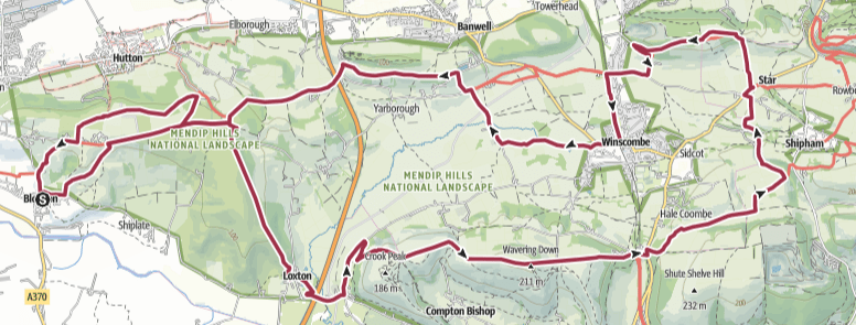
“West 31km”
31km with 740m elevation
This route cover the western section of both the BTU50K and BTU50M. On reaching the A38 after Wavering Down, it cuts east on the Mendip Way and then north at Shipham to return to Mendip Activity Centre.
“West 25km”
25km with ???m elevation
As Route 1, but skipping the loop via Bleadon.
West 31/25km pubs:
Mendip Activity Centre at Churchill, our Race HQ with café/bar
The Queens Arms at Bleadon (Route 1 only)
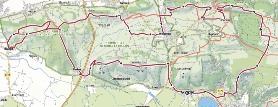
“East 3okm”
30km with 600m elevation
This route covers the eastern half of the BTU50K, and also some of the BTU50M between Axbridge / Cheddar and between Charterhouse / Winscombe.
East 30km pubs:
Mendip Activity Centre at Churchill, our Race HQ with café/bar
The Lamb at Axbridge
The Swan at Rowberrow
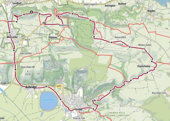
“West 42km”
42km with 1020m elevation
The full western half of the BTU50M, diverting at Cheddar to head north and rejoin the race route near Beacon Batch.
West 42km pubs:
The Queens Arms at Bleadon
The Lamb at Axbridge
The Swan at Rowberrow
Mendip Activity Centre at Churchill, our Race HQ with café/bar
“East 42km”
42km with ???m elevation
This route cover the eastern half of the BTU50M and cuts from Charterhouse to Cheddar (backwards along the 50k route) to close the loop.
“East 34km”
34km with ???m elevation
As above but cutting off the easternmost segment by taking the Monarch’s Way to the west of East Harptree.
East 42/32km pubs:
The Ring O’ Bells at Compton Martin
The Cider Barn at Draycott, (café and bar, not just cider!)
The Queen Victoria at Priddy

