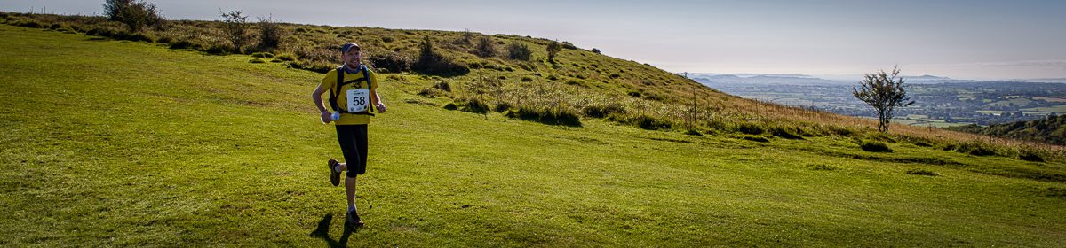
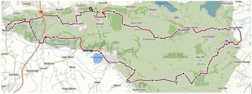
The Routes

BTU50 (50.5 miles, 81.4 km, 1960m ascent):

BTU50 website map and profile

(Note: Checkpoint 7 has been moved south to Winscombe in 2022)

BTU56 (56.6 miles, 91.2 km, 2480m ascent):

BTU56 website map and profile

(Note: Checkpoint 7 has been moved south to Winscombe in 2022)

There are seven checkpoints on the 50-mile race, eight on the 56. All but one of these are at Butcombe pubs and there’s a description of the route for each leg below.

The races are self-navigation (as explained on the Information page) and each competitor will need to carry 1:25000 scale paper maps which cover the route (PDF downloads below, paper maps will not be provided at registration).

MAP AND GPX FILE LINKS –  Updated 19 April 2022; current as of 10 January 2023

BTU50 –  OS website | GPX file (v1.7 – including 2022 changes at Cheddar reservoir and Winscombe, and correction above Rodney Stoke)

BTU50 printable OS maps (PDF)** 

BTU56 –  OS website | GPX file (v1.6 – including 2022 change at Winscombe)

BTU56 printable OS maps (PDF)**

If you are doing a recce of the route and find any inaccuracy in the GPX files, please email us to let us know.

ROUTE DESCRIPTION

Leg 1 – Swan, Rowberrow to the Ring O Bells, Compton Martin (8.8mi)

Heading initially downhill on the lane, this leg quickly asserts itself with some steep climbing, first up over the hill fort at Dolebury Warren then up onto Black Down which can be very muddy.  Some tracks and a lovely avenue of trees leads you to woods where you descend to Compton Martin, taking a turn left on the main road to get to the pub.

Leg 2 – Ring O Bells, Compton Martin to the Ring O Bells, Hinton Blewett (4.1mi)

After checking in at the pub the trail takes you back through the village to a right turn up a hill which leads you via fields and lanes to the village of West Harptree.  You’re only in the village for a few hundred yards (watch the traffic) then it’s out into the countryside again.  The hill up to Prospect Stile viewpoint is steep but you’re rewarded with some great views over the Chew Valley lakes if you have time to look behind you. The checkpoint is at the village hall, 100m further along the route from the pub.

Leg 3 – Ring O Bells, Hinton Blewett to the Queen Victoria, Priddy (9.6mi)

Hinton Blewett marks the easternmost point of the Butcombe Trail, and we divert from the marked trail here for a couple of miles via the Litton reservoirs and dam, rejoining the official trail at Coley. The way-marked route runs alongside the fast and dangerous B3135 for almost a kilometre on this leg, but we have negotiated a diversion for race day with local landowners which avoids it (note: this diversion is not a right-of-way and should not be used except on race day). After the road section there’s a lovely run through Stockhill Wood, past the Bronze Age “nine barrows” and on to Priddy.

The race day diversion is shown in red on this map – please follow the blue line for recces:

Red Quar 2019

Leg 4 – Queen Victoria, Priddy to The Rodney Stoke Inn (3.8mi)

The land opens up after leaving Priddy with larger fields and stone stiles.  A lot of the trail on this leg is along the top of the Mendip Hills and there are some great views of the Somerset Levels and Glastonbury Tor to the south. We divert off the way-marked trail just after the view opens up, and new for 2019, head downhill to The Rodney Stoke Inn (in Rodney Stoke!)

Note: Leg 5 differs depending on if you are running the BTU50 or BTU56

Leg 5 (BTU50) – The Rodney Stoke Inn to The Lamb, Axbridge (5.9mi)

A stiff 200m climb back up to the top of the escarpment brings back the fantastic views and the ridge is followed through the Draycott Sleights Nature Reserve. Following the descent, we’re diverting you off the official Butcombe Trail for the last kilometre into Cheddar to avoid a dangerous road section with a difficult crossing (take care when you get to the bottom of the descent and reach the road – the BTU56 splits off here). In Cheddar you pick up the Strawberry Line, a disused railway line now a foot/cycle track,  which takes you past Cheddar reservoir to Axbridge.  The checkpoint at The Lamb pub, overlooking Axbridge’s main square.

Legs 5A & 5B (BTU56)The Rodney Stoke Inn to The Lamb, Axbridge via The Swan, Rowberrow (11.8mi total)

5A (8.8 miles) – A stiff 200m climb back up to the top of the escarpment brings back the fantastic views and the ridge is followed through the Draycott Sleights Nature Reserve. Following the subsequent descent, the BTU56 route takes a right turn onto the West Mendip Way just before reaching Cheddar (careful: the BTU50 splits here). Another lung-busting ascent brings you to the top of the south side of Cheddar Gorge, then a brief technical descent to cross the road and up again to the highest point on the north side, with stunning views of the Gorge, cliffs, Cheddar Reservoir and the Bristol Channel beyond. You will follow the Gorge rim for a while, then turn north across open countryside before descending through the forest of Rowberrow Warren, returning to The Swan for an intermediate checkpoint.

5B (3.0 miles) – From The Swan, the route is on-road for a short while before rejoining the West Mendip Way to skirt around the small village of Shipham. This is followed by a brief climb to the top of Fry’s Hill and more expansive views across the Somerset Levels. A thundering descent brings you down to Axbridge where you rejoin the BTU50 at the checkpoint at The Lamb pub, overlooking Axbridge’s main square.

Leg 6 onward is the same for BTU50 and BTU56

Leg 6 – The Lamb, Axbridge to the Queens Arms, Bleadon (8.6mi)

There’s some gentle ascent at the start of Leg 6 as the route climbs to Kings Wood and the trig point at the top of Wavering Down.  From there you head over to Crook Peak but turn right at the saddle before you get to the Peak itself.  There are some great views along here.  You cross the motorway just before Loxton and climb for a couple of kilometres to the top of Loxton Hill.  There’s a marshal point a bit further along then a kilometre of road followed by a nice run down to the Queens Arms at Bleadon, the westernmost point of the route.

Leg 7 – Queens Arms, Bleadon to Winscombe (6.0mi)

This leg starts with a steep climb, first on road for couple of hundred metres, then through woods.  At the top of the hill take a turn into a golf course and follow the trail along the edge of the driving range.  A mile later the route takes you east along a section of path you ran in the opposite direction on the previous leg.  At the end of this, turn north and run to another bridge where you recross the motorway.  The lane you pick up on on the far side has great views south to Wavering Down which you ran over earlier in the day.  A nice flat section (diverted as from 2022) brings you to the final checkpoint where the Strawberry Line crosses the A371 at Winscombe. There are public toilets and a water tap here.

The route here was modified in 2022 due to the Hinkley Point Connection works. This new route is being retained for future years as it provides a safer road crossing and a better checkpoint location in Winscombe.

Leg 8 – Winscombe to the Swan, Rowberrow (4.0mi)

Leaving the checkpoint to the north, join the Strawberry Line and then rejoin the Butcombe Trail at Ilex Lane. It’s all reasonably flat for a while until there’s a switchback to the right after the site of Italian prisoner-of-war toilets and a long shallow climb to the top of Sanford Hill.  It’s then downhill to Star where you cross the A38, and a short hop, gently uphill, to finish back at The Swan.

Google Earth fly-by of the entire 50-mile route (from the 2018 start/finish in Draycott):

** PDF maps are © Crown copyright 2018 Ordnance Survey. Licence number 100060700. Maps 1-4 and 7-8 are the same for both races, 5&6 differ.

%d bloggers like this: