
BTU50M (50 miles, 80 km, 1960m ascent):


BTU50K (31 miles, 50 km, 1200m ascent):
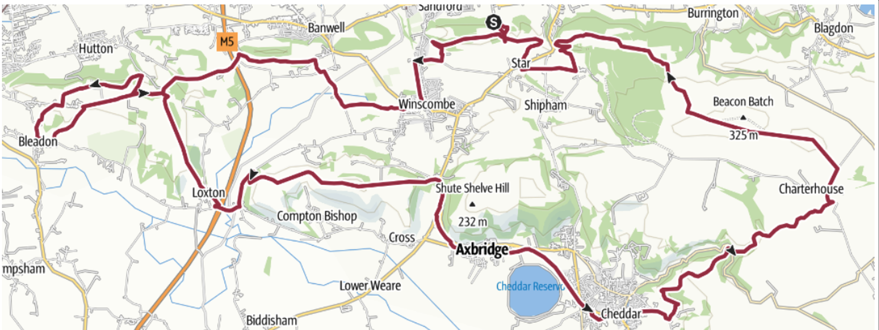

There are seven checkpoints on the 50-mile race, 3 on the 50k. Most of these are at or near Butcombe pubs.
The races are self-navigation (as explained on the Information page) and each competitor will need to carry adequate maps / GPS devices according to the kit list.
MAP AND GPX FILE LINKS
50 km: Outdoor Active | GPX (version 1.01, last updated 20/04/2025)
50 mile: Outdoor Active | GPX (version 1.0, last updated 17/04/2025)
Routes may be updated any time before the race, so please check here for the latest versions.
Recent changes:
v0.4 – Modification at Christon Hill to remove the out-and-back section (between Bleadon loop and main loop)
v0.5 – Modification just before Rowberrow to avoid using the road into the village (now comes along School Lane)
v1.0 – Modifications just before 50m/50k route split and just before Rowberrow (in both cases to take the short-cut along a path instead of being on the roads).
v1.01 – Correction to line of 50k route through fields west of Winscombe.
ROUTE DESCRIPTIONS
50 miles / 80km
2026 will follow the same format as 2025 with 50km and 50miles races running anti-clockwise from our Race HQ at Mendip Activity Center.
There are 7 checkpoints:
| 50 mile / 81km race checkpoints | Leg distance | Total distance |
| Bleadon (Youth Club BS24 OPG) | 15 km | 15 km |
| Axbridge (The Lamb Inn BS26 2AP) | 12 km | 27 km |
| Draycott (The Cider Barn BS27 3RU) | 8 km | 35 km |
| Priddy (The Queen Victoria Inn BA5 3BA) | 6 km | 41 km |
| Hinton Blewett (Village Hall BS39 5AY) | 15 km | 56 km |
| Compton Martin (The Ring O’ Bells BS40 6JE) | 7 km | 63 km |
| Rains Batch (Wireless Station BS40 7XX – no vehicle access for spectators, see NOTE for info) | 7 km | 70 km |
| Mendip Activity Centre (BS25 5PQ) | 10 km | 80 km |
31 miles / 50 km
The race is new in 2025 is just over 50 km with 1200m of ascent and also starts at Mendip Activity Center, following the 50 mile route along the Butcombe Trail anticlockwise. This continues as far as the checkpoint in Axbridge and through Cheddar before leaving the Butcombe Trail and cutting north via the beautiful but steep Cheddar Gorge to rejoin the 50 mile route at Beacon Batch and then back to Mendip Activity Center.
There are 3 checkpoints:
| 50 km race checkpoints | Leg distance | Total distance |
| Bleadon (Youth Club BS24 OPG) | 15 km | 15 km |
| Axbridge (The Lamb Inn BS26 2AP) | 12 km | 27 km |
| Rains Batch (Wireless Station BS40 7XX – no vehicle access for spectators, see NOTE for info) | 13 km | 40 km |
| Mendip Activity Centre (BS25 5PQ) | 10 km | 50 km |
NOTE: There is NO VEHICLE ACCESS for spectators to CP7 (the Wireless Station at Rains Batch) because it is at the end of a single track lane and must be kept clear at all times. If you wish to see runners in that area, there is limited parking along Ubley Warren Drive and Blackmoor Reserve car park (BS40 7XR). Please respect the local community and park responsibly or it may compromise our permissions to hold the event in future years. Thank you.
We try to include many of the Mendips’ highlights in these routes including pretty villages like Axbridge, great Butcombe pubs at many of the checkpoints, the Iron Age Hill Fort at Dolebury Warren and the highest point in the Mendip Hills – Beacon Batch. On the 50 mile route you will also visit Litton reservoirs and dam with lovely spring flowers at the furthest east point. On the 50 km route you will climb the side of the spectacular Cheddar Gorge followed by the peaceful Velvet Bottom nature reserve. And throughout you will enjoy stunning views over the Chew Valley to the north, Somerset Levels as far as Glastonbury Tor to the south, and east towards the Bristol Channel.
